![]()
the Phoenicians
It may come as a surprise to discover that a small group of Phoenicians may indeed have lived in New Zealand, around 600 years before the Birth of Christ.
The Phoenicians were capable explorers - They were among the first to trace routes to the western Mediterranean and beyond the Pillars of Hercules (the Straits of Gibraltar) toward the Atlantic coasts of Africa and Europe.
They divided the circle into 360° and established reliable celestial navigation.
They reached the English Channel and found tin in Britain. They sailed as far as the Canaries - and probably America and Brazil.
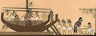
At the end of the seventh century B.C., the Egyptian Pharaoh Necho commissioned ten Phoenician ships to sail right around the continent of Africa !
Herodotus, a Greek traveler and geographer, described this journey two hundred years later in his History, written sometime in the 5th century B.C. "We know it Africa to be washed on all sides by the sea, except where it is attached to Asia." "On [the sailors'] return," Herodotus continues, "they declared that in sailing round Libya they had the sun on their right hand," or were sailing north and east.
He was troubled by this, but it verifies the account - in the Southern Hemisphere, the sun would indeed be to the North. It took the sailors 3 years to circumnavigate Africa.
If Amundsen or Capt Cook could navigate the Southern Hemisphere, why couldn't one of the first and greatest seafaring races ?
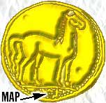
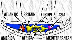
The coin shown above is thought to represent a map of the world, shown below. Minted around 350 BC.
Phoenicians in the South Pacific?
We
have strong evidence that they did in fact sail to Australasia. The following
image is a rendition of some of 250 hierolglyphs carved into the walls of a cave
in the Hunter Valley, NSW, Australia.
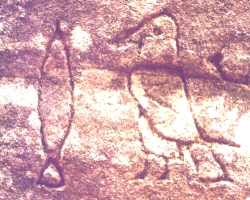
They are not aboriginal. They have been assesed as pre-dating the Middle Egyptian period, the Third Dynasty, between 1779 and 2748 B.C.
They chronicle the shipwrecking in a strange and hostile land, andthe eventual death of Lord Djeseb.
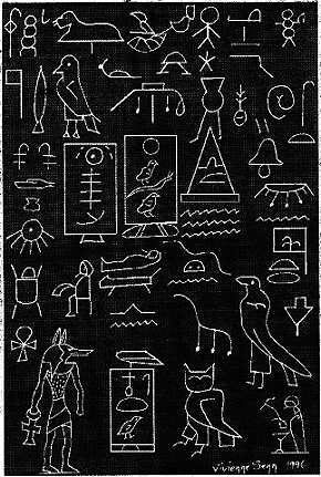
Below, some sketches of other hierolgyphs.
More information about the 4,000 year old site, click here.
These people were in all likelihood killed by the catalcysmic eruption of Taupo in 186 AD, a volcanic rendering of the North Island that has been described "the most violent and explosive known" to man, a truly catastrophic explosion from the bowels of the Earth.
The eruption created a plume twice the height of that of the eruption of Vesusius, towering some 50 km (30 miles) into the air.
50 km (30 miles) downwind, ash was deposited 1 metre (3 ft) thick.
Walker (1980) has described the eruption as ultraplinian. The Chinese recorded the Taupo eruption, with the dimming of the stars from the volcanic dust that entered the atmosphere and drifted around the globe. Lake Taupo was re-drawn on the face of the map.
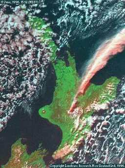
Mt Ruapehu, to the South, is still an active volcano. This is a satellite photograph of the eruption on June 17 1996, streaming 20 km or so into the atmosphere.
Mount Tauhara is near Lake Taupo, in the center of the North Island. The rock drawing below, discovered by local archeologist Perry Fletcher, is on the mountain, in a place where Lake Taupo would be spread out below like the blue, scintillating lake that it is.
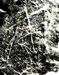
Tauhara rock drawing (above)
(inverted
from a positive to a negative for better viewing)

A schematic of the drawing (above)
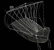
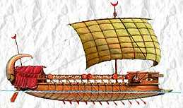
An actual Phoenician ship (above) Compare this to the preceding
image
This etching looks like a sailing ship, viewed from an elevation, and as if the observer were watching the ship sailing away - as if seen on the mountain, from that very spot where it was found ... and there are more etchings.
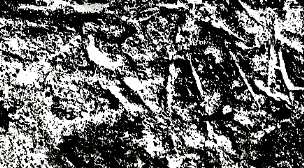
On
the southernmost peak of the crater, dated from the same time as the engraving
above, this inscription has been found - and both rock carvings were made with
metal tools, known to the Phoenicians, but not the later Maori settlers.
(image below and again negative shown for clarity)
The schematic
produced looks like this (below)
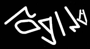
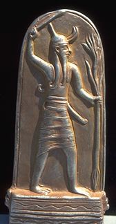
which translates as "Voice of one Baal". We know that Baal was the main god of the Phoenicians, and a weather god, familarily represented as a bull.
Phoenicians in the South Pacific ?
Maori regional tradition is that their first arrival found an altar on this Mountain, and it is on this "altar rock" that the inscription was found. Baal was worshipped in the open, at places like this, and on the rock, more notches have been carved for the passage of purifying water.
An image of an Arab dhow has also been carved on the same rock as the inscription above, probably by these later explorers.
In conclusion, if we apply the test of Occam's Razor - in which the simplest answer is usually the accurate one - and we ask who would leave Phoenician relics behind, at the time of the Phoenicians, depicting a Phoenician vessel, evoking worship of a Phoenician god, then the simplest answer - even if it defies agreed wisdom - is Phoenicians.
But of course other seafarers were also to discover this country ...
This
Web Directory will always be dynamic ~
all details are flexible and changing