![]()
the Ptolemaic Greeks
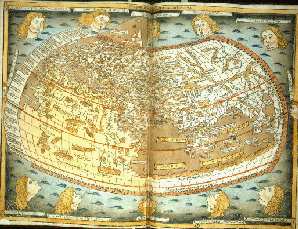
This (image above) is the famous Ptolemy map of the world, as known by the Greeks two hundred years before the birth of Christ.
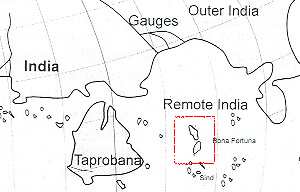
It was produced by Claudius Ptolemaeus, or Ptolemy, in 151 AD. If you look at the schematic beneath, the land mass marked Taprobana is not Ceylon as previously suggested - it's Australia ! Tasmania is even included.
As that is Australia, then the 2 islands named Bona Fortuna (boxed in red) look like - and would be - New Zealand.
At least one hypothesis suggests that a Ptolemaic king, maybe Ptolemy VI, financed a circumnavigation of the Earth about 180 BC, and from the Red Sea, he sailed straight into the Pacific Ocean.
Ptolemaic coins have been found in Northland. The first coin was found by leonard Schmidt about 1950 on the beach at Okiato Point, in the Bay of Islands - a Ptolemy VI bronze coin that would have been in circulation from 181-145 BC.
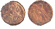
The second was an almost identical coin, found in Auckland, dating from 221 - 204 BC.
Once again, if a European could get into a wooden boat and come sailing right around the world to bump into NZ, why couldn't an Egyptian from a culture and wisdom that was at least 4,000 years old at the time ? And if an Egyptian didn't, then who provided the remarkably accurate information on the Ptolemy map?
This
Web Directory will always be dynamic ~
all details are flexible and changing