![]()
the Portugese discoveries
The Portugese navigated New Zealand, and took away with them remarkably accurate maps. They also left evidence of their passage.
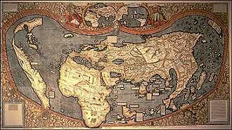
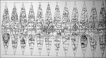
Probably the most famous map - now lost - was Toscanelli's 1474 Map of the World, and Christopher Columbus carried it with him when he bumped into America. This is a reconstruction:
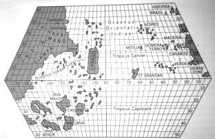
click on map for larger image
The Southern Ocean on the Toscanelli map shows a lot of empty space, and a lot of un-discovered areas. If however, we do an experiment - take the individual land masses shown in the lower lef-hand area as Java Major and Java Minor etc and lump them together, this is what we get (image below). It looks remarkably like Australia.
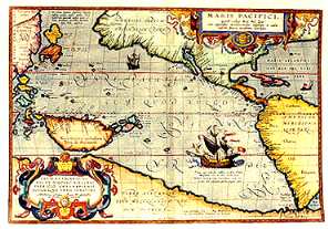
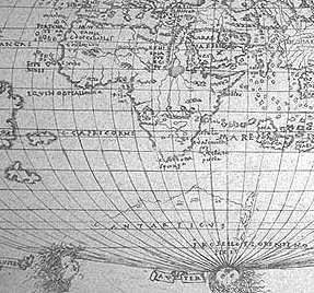
From the 1530's most European maps showed a northward peninsula jutting out of Antartica, with the inscription "Terra Australis recenter inventa 1499". ie. Australia discovered 1499.
It's clear that the discovery was made by a ship sailing North, then West, then South (because of the wind and ocean currents) from the tip of South America. All maps show what must be the East Coast of New Zealand, to be explained further.
Who discovered Terra Australis in 1499? Or had it been previously been charted, eg, by the Arab captain Abharah aka Sinbad?

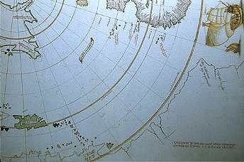
One (Paris globe c1535, image
below) map may also show a short stretch of the NSW coast as well as
the Antartic.
Another, lesser quality, is the map (below) by Orontius Fineus in 1531 - copied almost identically by Ortelius in 1589 - and then the infinitely more complex map of Martin Waldseemuller's of 1507 (second below).
This is a detail of the Waldseemuller's map above, from the Asia/Pacific area. Look familar?

The detail from the Francesco Roselli map (below) 1508, again shows the northward peninsula of Antartica, and the detail from the Vesconte Maggiolo map (second below) 1511, shows clearly the region is now being navigated and charted.
In 1535 , and using Mercatore's method of dividing a flat map into segments, or "gores" to accurately convey the sphere it represents, the world map of Georg Hartmann (second below) shows a specifically defined Antarica, again with the peninsula.
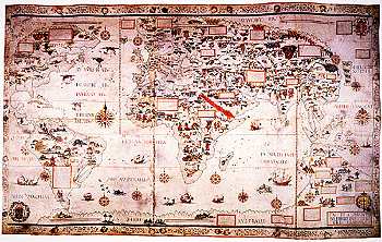
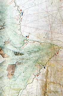
In 1550 Pierre Descelier presented this world map (image below) to his King, the Dauphin Henri II. It is an extremely detailed and famous map.
It is thought that Joseph Banks had a copy aboard Cooks' "Endeavour"
and when the ship ran on to the reef in Australia in 1776, that Banks showed
Cook the map - and they saw that a safe harbour was indicated in north, despite
knowing that northward meant more reefs. They went north. They were confident
that the maps were accurate
Even more striking is the simple question - if Cook arrived in New Zealand with Portugese maps, and knew already that East Cape was named Gulf of the Portugese - which he recorded - why would he, or anyone else believe that he preceded the Portugese ?
The only answer is that the Portugese themselves had been too secretive.
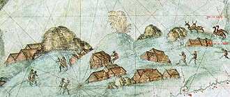
If we examine more closely the details on the Dauphin map, similarities - even accuracy - are striking, and given the cartography of the time they are, in places, even more perfect than Captain Cook's. This includes representations of Howes Island, Fiji, Norfolk, Fiji, New Guinea, and the North Queensland coast (images below)
 |
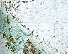 |
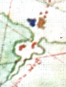
Compare also the enlargement of a section of the Dauphin map below, with the outline of the entire NZ eastern coastline.
 |
 |
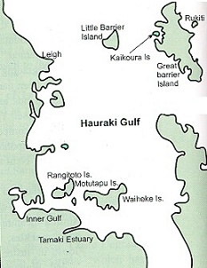
This
is the Hauraki Gulf (images below). The 2 inner islands
on the Dauphin detail are Rangitoto and Waiheke Island. The 2 outer islands
are Little Barrier and Great Barrier.
 |
 |
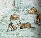
These are representations of communities. Look at the large, flightless, long-necked birds being hunted - Moa ? The indigineous aboriginals of Australia did not have huts in this manner, so we could assume this is a picture of Maori life.
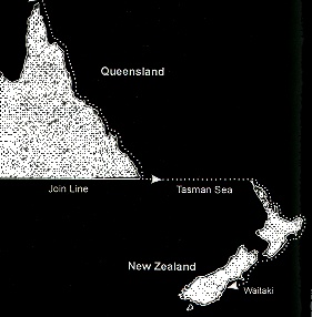
But on the Dauphin map, the Queensland Coast and the East Coast of NZ are joined together as one landmass, one continuous coastline. We know they're not - they're thousands of miles apart.
But where they join on the map, they are on the same latitude, a direct line across the Tasman Sea from Botany Bay to Cape Reinga! (see illustration below)
So who navigated, plotted and recorded the details for this map, and why did they break off as they came down the Australian coast, sail thousands of miles to the East, and then resume their mapping along the New Zealand coastline?
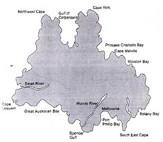
In Europe, in 1519, learning of the voyage that Magellan was about to undertake - to map the Spice Islands into the Spanish sphere of influence - King Manuel of Portugal sent a fleet under the command of Albuquerque to Goa, and thence on to "find the Islands of Gold". One of the ship's captains was Cristoval de Mendonça. By all accounts Mendonça arrived, with another ship captained by Pedro Eanes, at Cape York (the tip of Queensland, Australia) which was the outer limit of Portugese sea-knowledge in January of 1522.
By the end of 1524, Mendonça was to sail down the coasts of Australia and NZ, out into the Pacific, and finally to report back to King João III. If we allow him 5 months returning to Portugal from Goa, and 2 months returning from cape York, then his round-the-Pacific expedition would have taken 2 & 1/2 years. He described his encounters inside the Great Barrier Reef as "The Dangerous Coast" and clearly marked the coastline as he travelled south, including the reef now known as Cook reef where Cook ran aground. Great Sandy Island is marked on the map, and he seems to have continued south as far as Botany Bay. What happened then ?
One hypothesis is that Mendonça and Eanes opted to sail NE rather than SE to climb away from the onset of winter. If that's what happened, then their course would have found Lord Howe Island, Norfolk Island, and finally Fiji - and all three islands are clearly marked on the map. Arriving in Fiji, it is likely that the two ships would have split up, now that they knew they were in a vast ocean, and while Eanes was to sail back west to the Australian continent and then south, Mendonça would sail to the south.
Eanes reached Cape Howe. In 1963, in 250 feet of water, a local fisherman, Olav Mannes, trawled a vase to the surface. It was thermolinescence dated as 16th century, of Portugese origin. If Eanes had been in trouble with his ship, he may have been able to reach a safe harbour at Warrnambool. The ship was beached and abandoned. In 1991 the Victorian Government offered a 1/4 million dollar reward for the discovery of the sailing ship, known as the "mahogany wreck"; it is still buried in the dunes, but relics have been found. They include sword, rapier hilt, pewter jug, soike, and a galley latch. Eanes and his crew would not have survived long on the continent.
With a 15-20 knot wind over her starboard beam, Mendonça, leaving Fiji, would have sailed straight into New Zealand, and it would have probably been around September 1522. They would have landed in the Bay of Islands, judging by the Dauphin map.
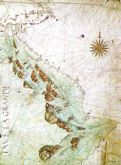
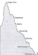
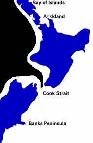
The image below represents the Portugese map of "Illo Do Magna". It is incredibly true to the actual shape of New Zealand. The inserts show modern-day localities.
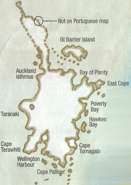
The Maori would have been hospitable, and we may wonder if the observations of Du Fresne, 200 years later, on the fairskinned and redhaired people he discovered, weren't a result of the inevitable fraternisation between the Maori and the Portugese here in what Mendonça called the "Gulf of Bays"?
His next stop was "New Bay" or the Waitemata Harbour, in modern-day Auckland, and then down the coast around East Cape that he named "Cape Beautiful" and halfway between the two islands, into Cook Strait, which he called "The Ravine". He marked on his chart cape Campbell and the Kaikoura Peninsula. Capt Cook had drawn Banks Peninsula as an island, but Mendonça marked it as it really is, so he may have anchored there, and explored inland. We do know that he anchored at the Waitaki River, where the map stops. He inspired a rock drawing there, at Takiroa - and either he, or one his crew, drew one themselves at the Duntroon Rock Shelter.
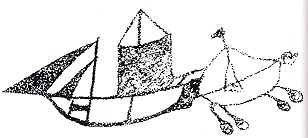
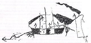
This drawing from Takiroa,
regarded by today's Maori as being of pre-Tasman origin, shows a caravel-type
ship and a longboat being rowed, and appears to be Ngati-mamoe. Radio-carbon
dating of deposits at the site suggest they were occupied between 1100 and
1500 AD. The mainmast shows a half-lowered large mainsail, with genoas on
the bowsprit. There is a large rudder on the stern, anchor at the bow, poop-deck
above the rudder. The ships boat carries a jury-rig, is flying a streaming
flag, and is being rowed. Below is an image of such a ship.
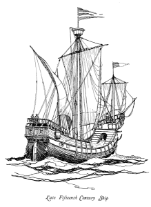
This ship would appear to be dragging it's anchor. Men are scurrying up masts and a sailor appears to be unfurling a sail. Are they rocks under the bow, or waves indicating a backwards slide of the ship? One of the sails has broken loose and is flapping in the wind as a sailor attempts to retrieve it.
This drawing was discovered at Duntroon, near the Waitaki River, again in a cave deserted since the 16th century.
It is here in the deep south of NZ that the last Moa survived, and it is likely that Mendonça would have accompanied Maori on a hunt for provisions. It is probably here that he saw the huge birds that would be extinct by the next century, and that he reproduced faithfully on the map.
Mendonça was given the post of Governor of Ormuz, an island in the Persian Gulf, for his faithful service, and he may have been followed to New Zealand, around 1530, by his master in Goa, the navigator Le Testu. Le Testu produced two in 1547, showing the Queensland coast, and an island called "La Joncade" which, translated freely means "the abundance of mangroves" image below.
This "island" appears to be a map of Northland.
If Testu had arrived across the Tasman Sea from Australia he may well have discovered Raglan Harbour, journeyed north, rounded the Cape and then explored back down the coast to the Hauraki Gulf. The Gulf disappears inland with a land bridge in places only a mile across. It could easily have been mistaken for a clear passage.
The Portugese (as was standard practice) would have gone to any length to keep their maps secret. Did Cook have a copy when he ventured into the Southern latitudes? There is evidence that he did.
This
Web Directory will always be dynamic ~
all details are flexible and changing