The earliest account of a fabled continent in the Southern Hemisphere, according to mainstream history, was by Bigot Paulmier de Gonneville, of Normandy, in 1504. There is an alternative view however, noted elsewhere in this site.
He claimed to have been blown off course, from the Cape of Good Hope, aboard the vessel "Espoir", landing in an unknown country, which he named "Terre Australe" ("southern land"), and lived there for 6 months.
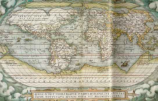
A French philosopher, as late as 1756
included this narrative in a work, "Histoire des navigations aux terres
australes" which was a compilation of navigational knowledge, as
well as the discoveries of Tasman ...
(and surely, reasoned cartographers of the time, there had
to be a huge land mass to balance Europe, Russia and the Far East in the Northern
Hemisphere)
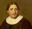
In 1642, having left the Island of Mauritius to find what lay in the Southern Oceans, Abel Janszoon Tasman, in command of 2 ships, the "Heemskerck" and the "Zeehaen", sailed towards mountains that had slowly appeared from the eastern horizon - and became the first known European to stumble across New Zealand.
Within days, the ships were attacked by the Island's inhabitants, the Maori - 4 of his crew were killed, at Golden Bay.
Tasman believed that he had found "Terra Australis" (click for image), a fabled continent that stretched across the Pacific from his present latitude to Cape Horn, 5,000 miles away !
Sailing north, Tasman's ships rounded the top of New Zealand, and again spied warriors on shore - who ferociously challenged the Europeans.
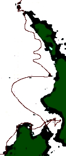
Tasman needed water on board, but was not going to see more men killed for it - he sailed further north, and east, into the Pacific Ocean to find landfall somewhere else on "Staten Landt".
A modern reconstruction of
his noon sightings is shown here, and the path his ships must have taken (image
below) after reaching the west coast of the South Island, and then
sailing northwards (to the top of the image).
None of his crew were ever to set foot on New Zealand soil, although he did annex it for Holland, as his ship disappeared over the horizon.
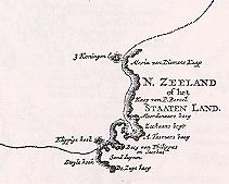
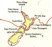
Tasman had pinpointed, and charted, portions of the coastline of the country - the large inlet shown as A.Tasman's Bay is actually a Strait between the 2 islands. Later, the name was changed from "Staaten Land" to "Zeelandia Nova" and then finally "New Zealand".
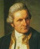
A little over a century later, in 1769, an Englishman who was to become the greatest explorer of his time, scudded in from the Pacific - Captain James Cook.
After sailing many 1,000's of miles of open ocean aboard "HMS Endeavour", he had found the most eastern promontory of the north island of New Zealand, and he declared it to be Young Nick's Head, in honour of the 12-year old who had been the first aboard to spy land.
He had no idea that a Frenchman, Jean Francois-Marie de Surville, was also sailing the New Zealand coastal waters - their ships, "HMS Endeavour" and "St Jean-Baptiste" had passed each other at only 25 miles, just enough to be below the horizon - and M. de Surville later anchored in Hokianga Harbour, then Doubtless Bay, in the upper North Island.
M. de Surville was searching for Terra Australis, and for trade opportunities, having journeyed, laden with spices, from Pondicherry, India.
He lost 3 anchors in a storm (one is in Te Papa national museum), and then after losing a longboat, M. de Surville lost his temper, and fired native whares and siezed a chief. The chief died of scurvy, 10 weeks later, and was buried at sea. M. de Surville soon joined him, dying in the surf off Peru
Captain Cook meanwhile discovered, as had Tasman before him that the inhabitants of New Zealand were fierce, and 2 attempts at contact saw four of the local Maori shot dead.
Sailing north, Cook came across friendlier Maori and was able to trade, eventually to go ashore on this land that the Maori called "Aotearoa", and to discover their complex society. He felt obliged, at Gisborne, to hoist the Union Jack, claiming NZ for King George III.
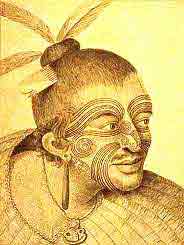
The botanists Banks and Solander were often ashore recording the unique specimens of plant life, later collecting 400 new species, and the artist Sydney Parkinson drew the natives, recording their moku, or facial tattoo, distinctive facial carvings that convey the heritage, the ancestry, of that person.
Over the next 4 months Cook was to sail completely around New Zealand, carefully charting 2,400 miles of coastline, shown below. He then sailed west, towards the large area of ocean where it was suspected the large land-mass of "Terras Australias" lay.
While Cook would then chart much of Australia's eastern seaboard - and find himself perilously running on to the coral of the Great Barrier Reef in the process - later managing to get back to London, he would not have known that he would soon be back in New Zealand.
This
Web Directory will always be dynamic ~
all details are flexible and changing